
The Ultimate Big Sur Road Trip Itinerary By a Local


Special note: I’ve traveled to Big Sur more times than I can count; it’s one of the best road trips in California. I also ran the Big Sur Marathon, the most stunning run in the country. As of this writing, 3/19/24 Hwy 1 is closed from McWay Falls to Limekiln State Park due to road erosion from California’s heavy rains this year. Check road closures before you go. I just came back from Big Sur in March. The closure added more driving to the trip, but we did it and had fun! There is still a lot to see. Because of the road closure, it makes more sense to start from the north. (Carmel and Monterey)
There’s something truly magical about the rugged beauty of Big Sur that never fails to captivate me. Having lived in LA and San Francisco, I’ve driven to Big Sur many times, starting from Northern California and Southern California; I’ll touch on both drives in this article.
Travelers come from all over the world to witness Big Sur for a good reason: it’s one of the most beautiful California road trips, especially in a convertible, which I’ve done twice and highly recommend.

Big Sur Road Trip Itinerary: The Details
- Known for: California’s most scenic drive
- Location: Central California. A 90-mile stretch of California’s rugged coastline between Carmel and San Simeon
- Essentials: A car, a full gas tank, a map, a sweater, water, and binoculars!
- Check this website for current highway conditions before you head out.
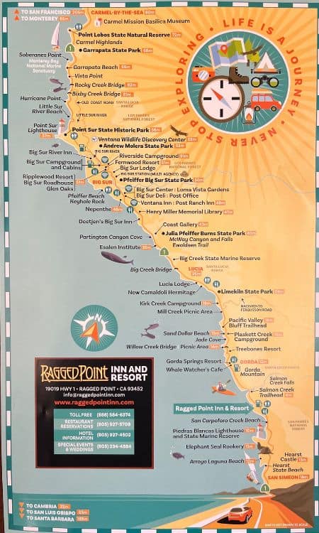
- Must see: Julia Pfeiffer Burns State Park, McWay Falls and Bixby Bridge
- Best time to go: April through October. November to March is off-season, it will be less crowded, but some businesses have limited hours of operation.
- How long do you need: 1- 3 days
- How to get there: Hit Highway 1 (the PCH), baby!
- There is no wifi (really, like none) starting right after Carmel at Point Lobos. Bring a map or download one.
Where Is Big Sur?
Big Sur is a rugged and picturesque stretch of coastline along California’s iconic Highway 1 (also known as the Pacific Coast Highway, or, as locals call it, “The One”), renowned for its dramatic cliffs, pristine beaches, and towering redwood forests.

If you’ve seen HBO’s Big Little Lies, you’ve seen parts of Big Sur.
Situated between Carmel and San Simeon, a 90—mile stretch of gorgeous undeveloped California coastline, Big Sur offers breathtaking vistas and a sense of serenity that captivates travelers worldwide.
It’s considered Central California.
What I love about Big Sur is that there are no traffic lights, strip malls, or chain stores. It is pretty undeveloped, and few people (besides tourists) live there. I love getting lost in Big Sur; it feels like you are “away” from it all.
Best Time to Visit
The best time to visit Big Sur is in March when the weather is stunning and the crowds haven’t descended yet.
I just drove to Big Sur in mid-March, and it’s lovely this time of year.
Understanding the best time to visit Big Sur requires understanding its seasonal dynamics.
Big Sur in March signals the start of spring’s bloom, yet Big Sur in December unveils a serene, less crowded experience, although chilly.
Each season transforms the landscape, offering distinct charms.

Spring and fall promise temperate weather and are ideal for those seeking mild conditions and vibrant hues. With its gentle ocean breezes, Big Sur in October presents a golden opportunity for photographers and nature lovers alike.
Summer beckons with sun-drenched days but also brings throngs of visitors.
This period, from Big Sur to San Francisco, sees an uptick in the traveler count, making solitude a rarity.
Conversely, winter offers a unique perspective, with the potential for rain enhancing the region’s mystical allure.
Consider these seasonal nuances for those planning a weekend in Big Sur or contemplating the distance to Big Sur for a day trip. They significantly impact both the experience and accessibility of this coastal haven.
For a deep dive into what to pack for a California road trip, check out our,
California Road Trip Essentials: Your Ultimate List
How Much Time Do You Need in Big Sur
I’d like to stay in Big Sur for a month, but if you’re coming for a visit and don’t have much time, you can see Big Sur in a day, but preferably two to three days is ideal.
If you want to enjoy some of the gorgeous hiking and beaches in Big Sur, you’ll need a couple of days; if you just want to do a drive-by of major stops, you can do it in one day.
If you have the time, there are some stunning hikes, especially in Point Lobos and Julia Pfeiffer State Park, that could take a day at least to explore.

Some Things to Know Before Your Big Sur Road Trip Adventure
- Bring a map. There is no cell phone service in Big Sur. Like, none. So, you will need to download a map to your phone before you head out. Most restaurants, bars, and hotels offer wi-fi service (not Nepenthe, which was a surprise), but you won’t have it on long stretches of the PCH.
- Fill up the gas tank before heading out. There are a few gas stations in Big Sur, but they will cost you about $6.0 per gallon. Gas up in Carmel or Monterey before you are in remote areas of Big Sur.
- After heavy rains, mudslides can wreak havoc on HWY 1. Check this site for up-to-date highway conditions. The last time I went Pfeiffer Beach and Keyhole Arch were not accessible and large parts of Hwy 1 were closed. There’s still a ton to see!
- Bring a sweater and jacket. Big Sur can get chilly, especially at night and after a sweaty hike when your body temperature cools and your clothes are damp. The air off the ocean is surprisingly chilly.
- When you stop at a convenient store in the area, grab a free map. Big Sur’s free tourist newspaper comes with an excellent map of the area.
- Plan ahead. Restaurants, hotels, and tours book up quickly in Big Sur. People from around the world come to drive the California Coastline. Make sure you make reservations before you hit the road.

How to Get to Big Sur
I have driven from San Francisco to Big Sur several times, as well as from Los Angeles to Big Sur. Each is very different but also the same.
North to South or South to North Debate
When the entire PCH is open, it doesn’t really matter from which direction you drive to Big Sur. However, with large chunks of the PCH closed, it makes sense to start from Carmel and Monterey (north to south).

Driving north to south means:
- You’re driving on the side of the road closest to the Pacific Ocean
- Most of the major pull-offs are on the side of the road closest to the ocean, so it’s easier and safer when coming from Monterey (north)
- If coming from LA, you have to start from the north anyway because large chunks of the PCH are closed. So until the road south of McWay Galls opens, start from the north and head south to Big Sur.
Comparing Northern California to Southern California is like comparing apples and oranges; they have very different terrains and scenery.
Renting a car: If you’re coming from out of town, you’ll need to rent a car to see Big Sur. When I rent a car anywhere, I use Discover Cars. Discover Cars is a search tool that allows you to compare companies and rates to help you find the best deals.
🏆 BEST CAR RENTAL COMPANY: DISCOVER CARS
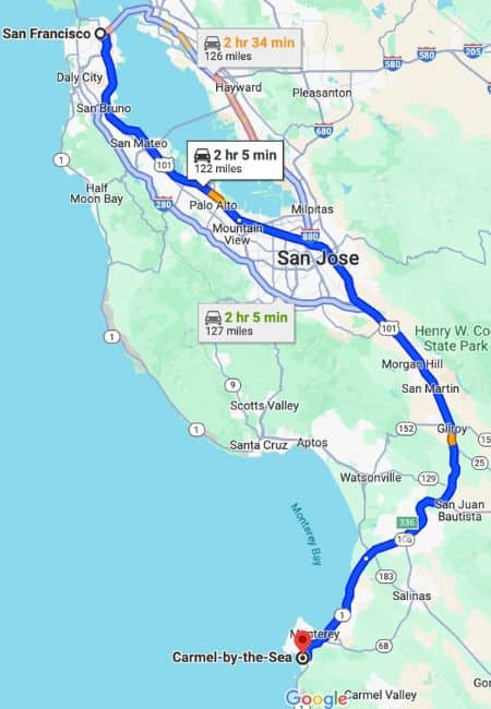
When booking your Los Angeles or San Francisco car rental, I recommend using Discover Cars. They search both international corporations and local LA companies to find you the best deal.From San Francisco to Big Sur
If coming from out of state for your West Coast adventure, it’s best to fly into San Francisco Airport (code: SFO), rent a car at the airport, and drive the 110 miles to Carmel (the north end of Big Sur), which will take about 2 1/2 to three hours.
I use Skyscanner to find the best airfare rates.
From Los Angeles to Big Sur
Alternately, you could fly into Los Angeles International Airport (code: LAX), rent a car and drive to San Simeon, take in the Hearst Castle (a favorite of mine) at the southern end of Big Sur.
Then, continue up the coast to Carmel-by-the-Sea. (This is not possible as of this writing, 3/19/24, because of road closures. Check road conditions before you head out so you know what to expect.)
If you leave from Los Angeles, the drive is longer and takes about 5 hours with stops; I just did this drive recently.

What to Do and See on Your Big Sur Road Trip
Finally we get to the good stuff! Woo-hoo!
If you’re traveling from NORTH to SOUTH, you’ll start in Carmel. There are a lot of things to see here. Carmel-by-the-Sea and Carmel Beach are a must and perhaps my favorite places in this area, including the 17-mile drive, the prettiest stretch of road in the country.
The 17-mile drive takes you by the famous Pebble Beach Golf Course. It can take hours to complete because there are so many scenic pull-offs to take pictures, but it’s well worth spending some time here before you drive to Big Sur.
Right next to Carmel is Monterey Bay, where the Monterey Bay Aquarium is a popular spot, as is Cannery Row in the middle of town.
Other areas to hit are Lover’s Point Park and Pavel’s Bakerei.
Now it’s time to hit the Pacific Coast Highway and get on with your Big Sur road trip.
1. Point Lobos State Nature Reserve
After exploring Carmel and Monterey, your first stop on your Big Sur itinerary is Point Lobos State Nature Reserve.
This is where Wi-Fi stops working. As a travel blogger, I find this part challenging.
Please don’t pass by this spot. Point Lobos is a must-do; it is stunning and a great place to see wildlife. We saw sea otters and a few seals floating and playing in the water. It was miraculous. Point Lobos captivates visitors with its unparalleled natural beauty and biodiversity.


Must Take Hike:
Once in the park (without Wi-Fi) from the road, head straight. When you see trail markers, take the trail furthest to the left, marked “South Plateau Trail.” This will take you on a beautiful, well-shaded hike (about 15 minutes) that winds through until you come to a bridge. You will pass ten markers, and at marker ten, there will be the bridge. Go over this bridge, and you’ll see China Beach, which is stunning! The Pacific Ocean is bright blue at this point. Once you get to the water, you can venture on other paths that are well-defined and marked.
Renowned for its dramatic cliffs, hiking trails wind through enchanting landscapes of cypress groves and wildflower-covered meadows, providing breathtaking vistas of the Pacific Ocean and opportunities for wildlife spotting, including sea lions, otters, dophins and migrating gray whales.
Must-do: Admire the sunset from Bird Island Overlook (on the southern part) and visit the beautiful China Cove.

Insider Scoop: Bring binoculars to spot wildlife in the ocean. Bring cash for the $10 parking fee. You can also park on the side of the road for free and hike to the park entrance. Visiting in winter is your best bet to see whales migrate up the coast.
2. Garrapata State Park Bluff Trail (waterfall alert!)
Garrapata State Park’s Bluff Trail is only about a 15-minute hike, so it’s great for non-hikers. And it has a waterfall! It spans approximately 2 miles along the rugged coastline, offering sweeping ocean views, hidden coves, and stunning rock formations to explore.
This is a great place to take more stunning photos of your trip.
If you are in Big Sur during spring, hit Calla Lily Valley right near Garrapata Beach; you might as well fit in both if you are in the area. It’s simply stunning from February to March.
Insider Scoop: Calla Lily Valley is a hidden gem 💎
3. Rocky Creek Bridge (Not the Bixby Bridge, but similar)

Some confuse this with the famous Bixby Bridge because they have a similar shape and style; the Rocky Creek Bridge is smaller but just as pretty. And there are great views of the bright blue ocean at its base.
There is a “no trespassing sign.” I took a quick photo and skedaddled. Be careful here; the top is steep.
4. Bixby Bridge
Just 15 miles south of Carmel-by-the-Sea is the iconic Bixby Bridge; you can’t miss it because you drive right over it on the 1 (as we locals call it). Also, even in March, everybody was stopped here taking selfies.

The bridge represents Big Sur, mostly because it is in nearly every photograph when Big Sur is mentioned.
Stop and get a photo; Bixby Bridge is an iconic part of the area’s breathtaking topography.
Insider Scoop: Because the bridge is iconic, traffic can slow to a standstill, especially during peak season (summer). In summer, hit the bridge in the early morning to avoid traffic. WARNING: tourists run across the road here from one side to the other; be careful not to get hit or hit anyone.

5. Old Coast Road
The Old Coast Road in Big Sur is a historic route that winds through towering redwoods and offers breathtaking views of the Pacific Ocean.
This scenic drive provides a glimpse into the region’s past and showcases its natural beauty.
Not many people know about this road; it was used long before Highway One was completed. This is private land, so drive on it, but I wouldn’t linger. There are “no trespassing” signs all over the place.
Insider Scoop: Old Coast Road isn’t paved. So don’t try this after a lot of rain. It’s private land, you can drive on it, but don’t stop for too long.
6. Hurricane and Sea Otter Refuge Viewpoints
The Hurricane Point viewpoint in Big Sur offers awe-inspiring panoramas of the rugged coastline and crashing waves.
The Sea Otter Refuge viewpoint provides a tranquil spot to observe these adorable marine mammals frolicking in their natural habitat along the rocky shores.
7. Point Sur State Park and Lighthouse
Point Sur State Historic Park and the iconic Point Sur Lighthouse offer stunning coastal landscapes, diverse wildlife habitats, and a rich cultural heritage.
Tours are offered on some days, take about three hours, and cost $15 per person. The tour is worth it because it delves into the lighthouse’s fascinating history and architectural significance.
As you ascend the winding path to the summit, you’re treated to panoramic views of the rugged coastline and rolling waves crashing against the cliffs. This offers an unparalleled vantage point for capturing the beauty of Big Sur’s coastline.
If you want to skip the lighthouse tour, the park offers great hiking with tide pools nearby.
Insider Scoop: Tours book up quickly, so book on the website in advance. They are only offered on some days. If you take the tour, bring a jacket. It is very windy once you reach the top of the lighthouse.
8. Big Sur River Inn
Ready for lunch?! This place is the perfect place to stop for an extensive menu, outdoor seating with umbrellas, or picnicking right next to the river for which it’s named.
9. Pfeiffer Beach (the purple sand beach and Keyhole Arch)
When approaching from the south, look for the turnoff around 1.8 miles after you pass Nepenthe Restaurant.
Alternatively, when coming from the north once you see the Big Sur Station on the left side of the road, take the second right turn to get to Pfeiffer Beach. It’s a hard right. You can’t miss it, take a right turn here 👇🏻

Pfeiffer Beach in Big Sur is famous for its purple sand beach and its other unique feature, the Keyhole Arch, which is just offshore of Pfeiffer Beach. It is one of the most Instagram-worthy shots in Big Sur (although it’s hard to pick just one; there’s so much natural beauty in this part of California).
This beach is a bit too cold for swimming, but it’s the best place to get great photos, and that is why you’ll see a lot of professional photographers hanging out here to watch for the light coming through Keyhole Arch, especially at golden hour.
Insider Scoop: When you see a big yellow sign that says “NARROW ROAD: NO RV’s OR TRAILERS,” drive down that road! It costs $10 to park but totally worth it.
10. Big Sur Bakery
It’s hard to live in California when your jam is baked goods (pun intended), and you’re trying to be healthy; this is another excellent California bakery.
This is a quaint and rustic cafe; the wait can be long but well worth it. We didn’t experience a wait because we arrived late in the day, and it was March. They close around 4:oo pm.
Jessica’s Picks:
- The ginger scone is the best scone I have ever had, and I have eaten a lot of scones.
- The Mocha cookie is a chocolate lover’s dream come true. PURE chocolate. It is dense, decadent and delicious.
- The cream-filled donut. OMG. Holy smokes! This was amazing. The best cream filled donut I’ve ever had. We had just hiked through Point Lobos, so we were really, really, hungry and we ate this donut so fast.
- The chicken sandwich—I’m actually still thinking about this one. It is like eating orange chicken from a Thai restaurant on a bun. It was outstanding, and so was the side salad that came with it!


As you can tell, we spent a ton of money at Big Sur Bakery. It’s not cheap. Or maybe, it’s not cheap when you order everything.
Big Sur Bakery has a limited menu of soups, sandwiches, baked goods, and salads. The baked goods are where it’s at here. It’s only about 3 miles from Pfeiffer Beach, approximately 10 minutes by car.
Insider Scoop: They have a public restroom, which is surprisingly hard to come by on road trips in California. If you’ve ever tried to go to the bathroom in Stinson Beach, you know what I mean.
11. NEPENTHE Restaurant
This is a great place to have a cocktail while looking at the stunning coastline on their outdoor deck. They have an amazing view, and the cocktails have a surprising amount of alcohol—probably because they are not cheap—$20 a pop! You’re paying for the view as well.

NEPENTHE stands on the site of The Log House, Big Sur, 808 feet above sea level, which was built by the old “Trails Club” in 1925.
Jessica’s Picks:
Order Nepenthe’s famous “Ambrosiaburger” sandwich on a French roll. The ambrosia sauce it comes with is tasty. Get it with cheddar cheese. It lives up to the hype. You won’t have another burger like this anywhere. Their basket of fries can feed a family of ten—no joke. Get a half-basket; it’s still quite large. The fries are made the way God intended, thin and crispy.
NEPENTHE is about 4 miles south of Pfeiffer Beach and takes approximately 15 minutes to reach by car.
12. Henry Miller Memorial Library
For a library, this has a cool vibe.
When I stop at the Henry Miller Memorial Library surrounded by giant redwoods, I feel like I’m in a 1960s film and Dennis Hopper is going to ride up on a motorcyle at any moment.
It’s all atmosphere and a local vibe here.
They serve free coffee while you can peruse unusual titles for purchase. This is the kind of place that makes me fall in love with California all over again.
13. Julia Pfeiffer Burns State Park – McWay Falls
Most people coming to Big Sur must see the famous 80-foot McWay Falls, which is stunning and flowing hard when I saw it in March.
The waterfall is about 11 miles past Nepenthe Restaurant, with the park on the other side of the highway.
McWay Falls is a bit difficult to see from the road right now. But if you hike into Julia Pfeiffer Burns State Park and take one of the many trails, you will likely see other waterfalls due to California’s heavy rains.
Good to know: you only see the waterfall in photos from the cliff above because beach and ocean access is forbidden. Trekking to the base of the falls is not allowed. Please respect this. There are plenty of other beaches in Big Sur with beach access and other waterfalls in the park to see.
Insider Scoop: The best time to visit the waterfall is in the afternoon when the sun illuminates the water. Bring $10 in cash for parking. Or park on the side of the road if parking is full. A bonus of parking in the lot is it has bathrooms! YAY. (As a woman with a small bladder, I like to pee sitting down). I love a reliable bathroom location shout-out.
14. Limekiln State Park
After Julia Pfeiffer State Park, head south to Limekilm State Park, which offers more hiking trails covered by giant redwoods and waterfalls. If you plan on hiking one of the short hikes (nothing too strenuous here), take a jacket or sweater; the weather can be cool because of the redwood cover.
Also, Big Sur is off the Pacific Ocean, so, it can be cold in Big Sur; people are always surprised about this, but I’m not being hyperbolic!
Insider Scoop: Bring $10 in cash for parking. Also, more restrooms are available!
15. Sand Dollar Beach
This is Big Sur’s largest beach during low tide. So if you’re looking for a beach you can lay on or enjoy a picnic, this is the best one for that.
During high tide, you won’t be able to do this, so check the tide charts before you plan a beach day on Sand Dollar.
Insider Scoop: Bring $10 in cash for parking. Also, more restrooms are available! You might be noticing a theme with parking. It’s usually ten dollars to park in Big Sur. Warning: there is a staircase (about 100 steps) to get down to Sand Dollar Beach; you’ll have to climb *UP* those steps to get back to the parking lot!
Where to Stay in Big Sur
Like everything else in Big Sur, accommodations are pricey. They are especially pricey because there are so few to choose from. You’ll find cheaper accommodations in Monterey and Carmel, but not by much.
Here are my picks for staying in the Big Sur area:
- Big Sur River Inn: This is 98 the Inn with the great restaurant I mentioned earlier. The restaurant and the fact that it is the most budget-friendly choice in Big Sur make it a winner. >>>Click Here for Prices
- Alila Ventana Big Sur: If you prefer luxury and romance (🙋🏻♀️), this hotel is for you! Pros: it’s adults only, has an amazing pool and a fabulous restaurant. Great for one-on-one time with a partner. >>>Click Here for Prices
- Fernwood Resort: This motel has a rustic vibe, with small cabins with mountain views. There is a restaurant and bar on the premises, but this is more of a place to sleep than hang out. >>>Click Here for Prices.
Where to Eat and Drink in Big Sur
Be prepared to spend money on the coast. Even convenience stores in Big Sur are pricey. You’ll be trapped between the ocean and no way out, and they know it.
Like most tourist locations on the coast (I find this in Malibu as well in some spots, not Nobu), food quality sometimes gets sacrificed when there is a stunning view to lure you in. This has always bothered me. Why can’t we eat excellent food at the same time there’s an excellent view to take in?!?

I haven’t tried every restaurant in Big Sur, but the ones I have tried were… decent, but not exceptional. With the exception of the Big Sur Bakery.
So, if you want to spend less money on food, pack a cooler of food and drink before you hit the food.
Here are some of my favorite spots to eat and drink along the PCH from Carmel to San Simeon:
- Cafe Kevah: Serves breakfast and lunch and has outdoor seating with stunning views. It is located below NEPENTHE restaurant.
- NEPENTHE: This restaurant is a staple of Big Sur and has been around forever. It has a Greek bent and is a great place to have a cocktail and watch the sunset. Some of the best views in the area.
- Big Sur Bakery: A great place for a quick bite for breakfast or lunch. They have amazing pastries, wood-fired pizza, and the quintessential California meal: avocado toast.
- Big Sur Roadhouse: Great place for coffee and a donut or a pulled pork sandwich and a beer.
- Alila at Ventana: Great views and great in-season California Coastal cuisine.
- Sierra Mar Restaurant: This is fine dining for a special night out. Located in the Post Ranch Inn.
- Deetjen’s Big Sur Restaurant: Cozy and rustic. Requires a reservation due to limited seating. Like a lot of California restaurants, they serve fantastic wine.
What to Pack for a Big Sur Road Trip
- Water Bottle: I never travel anywhere, especially in California, without my Water-To-Go Bottle. It has a water filtration system built into it so you can filter out harmful toxins and have safe water to drink no matter where you fill it up. > Buy Water-to-Go Here
- Beach Blanket: When you live in California, you always have a blanket in the trunk for the impromptu beach stop. > Buy My Favorite Beach Blanket Here
- Binoculars: A must to spot wildlife in the water, like whales and dolphins at Point Lobos. > Buy Binocular Here
- Car Charger: You will need a cell phone car charger on any long road trip so you don’t get lost and in case of an emergency. Unless you carry physical maps with you, which I recommend as well. > Buy Cell Phone Car Charger Here
- Sunscreen: The sun is strong in California, even when the weather is chilly. I don’t cross the street without a hat and sunscreen on my face 365 days a year. > Buy Sunscreen Here
- Sunglasses: Just like it’s essential to protect your skin, your eyes need protection too! > Buy Sunglasses Here
- Map of California: I like to have an actual map of the places I visit, especially Big Sur where coverage is spotty. It’s old school, but I like looking at maps. > Buy Maps Here
- Cell phone holder for car: I must thank my brother for this find; this is absolutely the best-designed cell phone holder for the vehicle. It’s genius. > Buy Cell Phone Car Holder Here
Big Sur Tours
Common Questions About Driving Big Sur

Is Big Sur worth the drive?
Yes, Big Sur is worth the drive. It is one of the prettiest places on the planet. You won’t find a more rustic, undeveloped, rugged coastline that is more stunning than Big Sur’s, even in Europe.
What is the most scenic drive to Big Sur?
The most scenic drive to Big Sur is taking Highway 1, also known as the Pacific Coast Highway. Big Sur is most well known as California’s most scenic drive. The question is, which is more beautiful, starting from the south in San Simeon or starting from the north in Carmel? Most people agree that the north-to-south drive is more beautiful, which means starting in Carmel and driving down the rugged coastline.
Is driving to Big Sur dangerous?
I have to admit, parts of the drive scare me. You’re right next to a giant cliff, and below the cliff is the ocean. Highway 1 can also be curvy at times. You must always pay attention, which is challenging when surrounded by so much beauty. Some parts of the road can be narrow, and you have a lot of tourists pulling off to the side of the highway to take photos. It is safest to use the designated pull-offs to stop and take photos.
How long does it take to the Big Sur coastline?
You can drive the entire Big Sur coastline in two hours without stops; with traffic, three. But if you want to experience Big Sur and stop at some of the places mentioned on this list, it can take a good two to three days.
Where does the Big Sur drive start?
The Big Sur Drive is a 90-mile stretch of coastline between San Simeon in the south and Carmel-by-the-Sea in the north. You can “start” anywhere, but most people start in one of these two locations.
Can you swim in the beaches at Big Sur?
You can; it’s not advised and can be very dangerous. Swimming in the waters of the beaches of Big Sur can be challenging due to several factors.
The waters along the Big Sur coast, like Pfeiffer Beach, are known for their strong currents, cold temperatures, and rough conditions. These make swimming risky, especially for those who have yet to experience or become familiar with the area.
It’s always recommended to check local conditions, seek advice from locals or park rangers, and never swim alone. Some beaches may have designated swimming areas during certain times of the year.
Why is Big Sur famous?
Big Sur is famous for its rustic, undeveloped beauty, giant redwoods, stunning blue ocean, and fabulous hiking. And for its beautiful bridges. There is nothing like Big Sur in the US.
- Book a hotel
- Book a rental car
- Best place to find tours
- Second favorite place for tours
- Favorite travel insurance
- My favorite travel item

California Travel Planning Guide
🚑 Should I buy travel insurance for California?
100% YES! – With basic coverage averaging $1.50 USD per day, enjoy peace of mind with a plan from SafetyWing, one of the biggest names in travel insurance. (Read more)
💦 Can you drink the water in California?
Yes — But I wouldn’t. It doesn’t taste very good and there are contaminants in it. You’ll want to buy a Water-To-Go Bottle, which filters drinking water while on the go (traveling) and helps keep you hydrated.
🚙 Is it safe to rent a car in California?
Yes — Renting a car in California is one of the best ways to explore this vast, awesome state, and kind of a must! I always rent with Discover Cars, which checks both international companies and local California companies, so you get the best rates. (read more)
🏨 What’s the best way to book my California accommodations?
For California hotels, Booking is the best site, but for hostels, use Hostel World. If you’re considering a California Airbnb, don’t forget to also check VRBO, which has better rates than Airbnb.
🧳 What do I pack for California?
Head to the Ultimate California Packing List to get all the information you need about packing for a trip to California.
🛫 What’s the best site to buy airfare to California?
For finding cheap California flights, I recommend Skyscanner.


